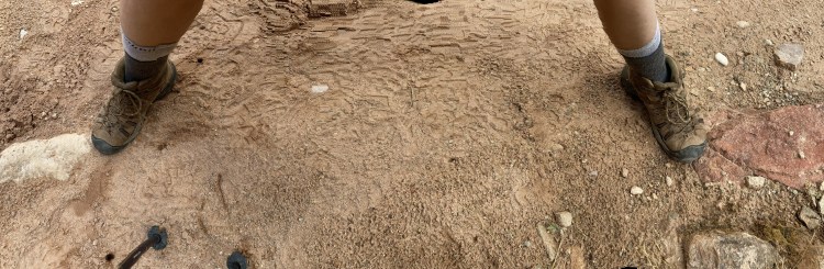
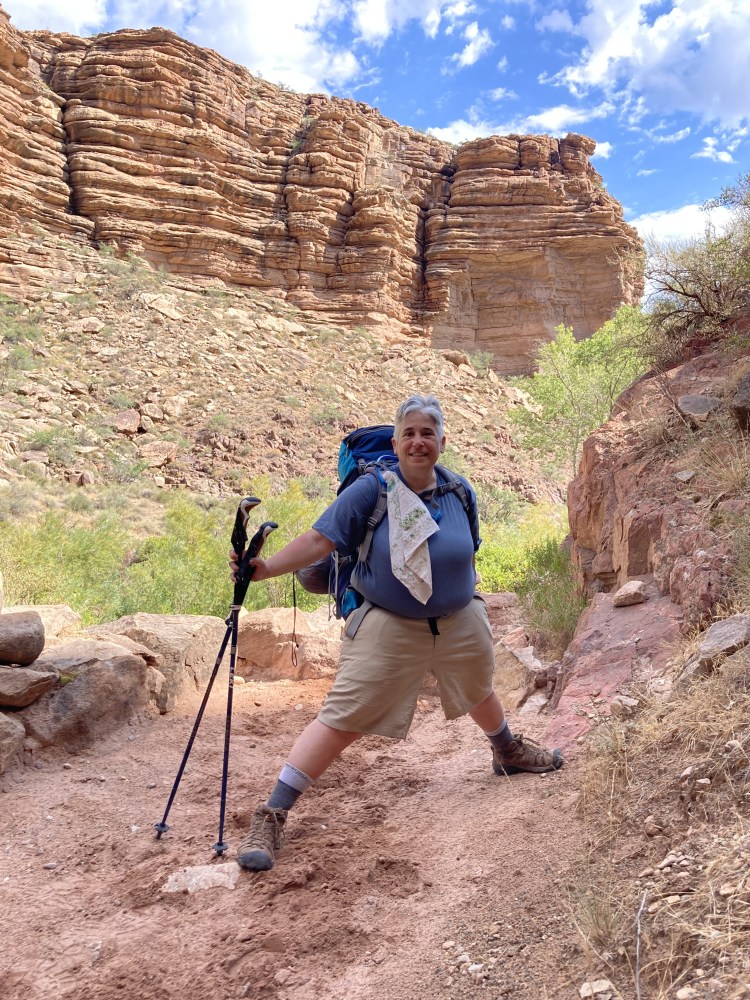
July 17, 2022 at 9:24 AM – My left foot is touching one of the Grand Canyon’s basement rocks known as Zoroaster Granite. My right foot is presumably touching the Tapeats Sandstone.
The place where these rocks meet is called the Great Unconformity. There is about 1.2 billion years missing between these two rock formations. The Earth is about 4.54 billion years old. That’s over 1/4 of the Earth’s existence!
Obviously a Lot Happened Here
Though the Grand Canyon now sits well away from an ocean, I find it helpful to visualize it as a once upon a time coastline, at times immersed in water or a shallow sea, at times covered in sand dunes or dry land with rivers and streams, or a delta with waterways flowing out to sea.
The oldest known rock in the Grand Canyon is 1.84 billion years old. So turn the clock back 1.8 billion years. The earth’s surface had long since cooled into plates, their constant movement forming and breaking apart supercontinents. Life on earth was small. Cyanobacteria had already filled the atmosphere with oxygen. Eukaryotes, the forerunner of life as we know it, emerged.
In the ongoing movement of the Earth’s crust, small land masses were making their way toward the Wyoming Province of the supercontinent of Laurentia. The Wyoming Province is a stable crust (craton) formed in the Archean age around 2500 million years ago (2500 Ma).
In an event known as the Yavapai Orogeny (orogeny = mountain forming event), a succession of collisions at subduction zones sutured the small land masses to Laurentia at the Wyoming Province.
The first to arrive was the Mojave province, an Archean age piece of continental crust with some volcanic activity. The next to arrive was Yavapai Province, a younger volcanic island arc (also called a chain), followed by the Mazatzal Province volcanic island arc.
The Grand Canyon’s basement rocks were formed at subduction zones as volcanic island chains collided with the continent that would become North America. The islands provided the volcanic rocks and sedimentary materials that created the Rama (1751 Ma), Brahma (1750 Ma), and Vishnu (1750 Ma) Schists and the Elves Chasm Gneiss (1840 Ma). Magma chambers beneath the islands created the Zoroaster Granite (1740 Ma).
The collisions formed tall mountains around 13,000 feet, known as the Vishnu mountains over deep chambers of magma. The Vishnu mountains eroded to sea level. With the weight of the mountains gone, the heated materials from the deep chambers rose to the surface leaving a sometimes churned or folded appearance when they cooled.
Ongoing plate movements assembled a new supercontinent, Rodinia. Far away collisions in the south compressed the whole southwest. The resulting NE trending folds were flooded by shallow seas. The Bass Formation and Hakatai Shale developed in the shallow seas.
As compression continued, the basins rifted along NW-SE faults. Shinumo Sandstone, Dox Formation, and Cardenas Basalt formed in an environment of rivers and floodplains. Intrusions of molten rock in the basins cut through the Bass, Hakatai, Shinumo and Dox layers as sills and dikes, exposed now along the North Kaibab Trail in the Dox above and below Wall Creek and below the Hakatai from above the Lower Jct to Ribbon Falls to the Bass the Box. Pressure of ongoing plate tectonics lifted the rocks at a 20 degree angle.
The Supergroup rocks eroded, leaving only a handful of locations where they can be seen in the Grand Canyon. The bright red, orange, and purple sandy slopes of Hakatai Formation are visible from the Rim. The South Kaibab travels through some of the Supergroup rocks. The Eastern canyon
Sedimentary rocks formed from sandy beaches, shallow seas, and rivers.
Tapeats is the lowest horizontal rock layer in this part of the of the canyon. Tapeats was formed in sandy ocean beaches 508 million years ago.
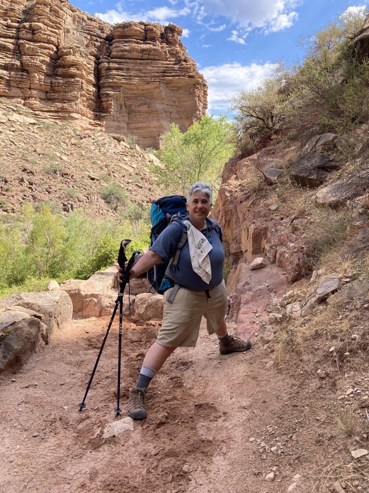
As the exposed granitic rock tapered off beside me, I thought I might have found what I was searching for, but I wanted to be sure. I checked up trail into Tapeats Narrows and then down trail into the granitic rock. Subtle changes in the sand color and more obvious and consistent changes in the exposed rocks in the trail both above and below confirmed in my mind that this was, to the best of my knowledge, the Great Unconformity on the trail itself. A friend from the campground arrived just in time to take my photo!
How did I get here?
My interest in geology developed slowly over several backpacking trips in the Grand Canyon.
I was sitting in Bright Angel Creek in June of 2018, cooling off in the mid-day heat. I scooped up a handful of rocks. They were all different colors and textures. There was one that had several sides, one purple, one green, one that looks like a buffalo, and one that looked like a pronghorn. I looked up at the cliffs. “How did you get here?” I wondered.
I reclined in the rushing water, drifting into a meditation, noticing that the rocks are keepers of the earth’s time. At in some point in space and time, maybe the big bang, we are related, made of the same stuff. None of these thoughts had ever occurred to me before, but it was all pretty straightforward.
I was tempted to take the rock, but I dropped it back into the water. Leave no trace. I had already moved the rock from its journey when I picked it up.
I got out of the creek, wrote down what had happened, and drew pictures of the rock.
Before dinner I sat in the creek again and scooped a handful of rocks. The same rock was in my hand. I wondered what it meant. It had to do with someday telling the rocks’ story. Buy how? I was totally ill equipped. It would be okay. I didn’t need to know right now. It would become clear.
A couple days later at the Yavapai Geology Museum, my eyes glazed over as I attempted to learn how the Grand Canyon was formed. I memorized layer names: Know The Canyon’s History. Study Rocks Made By Time, Very Slowly. Kaibab, Toroweap, Coconino, Hermit, Supai, Redwall, Muav, Bright Angel Shale, Tapeats, Vishnu Schist.
I tried to identify the layers as I looked out at the Canyon. This was hard. I figured out that some layers have a vertical drop and others are gradual. Supai has both. The gradual ones are harder to distinguish visually because they are covered in soil and plants. Coconino and Redwall were long vertical drops main them easy to spot. From there you could get your bearings.
There was also something called Zoraster Granite and something called the Grand Canyon Supergroup. These would have to wait. My head was full, but I had just enough room for one more piece of information. There was something called the Great Unconformity. What was it? Apparently 1.2 billion years of geological time had gone missing.
What did it mean that 1.2 billion years in geological time was missing? Where did it go? That’s a lot of missing time.
When I got home, I looked at photos I had taken from outside the Yavapai Geology Museum. I had never marked up a photo. After several mishaps I had a good first draft. Curiosity about place names led me to various maps, among them, geological maps. I created a project in Google Earth and plotted place names across the entire canyon. An interactive geological map of the Canyon allowed me to develop hiking guides so that I would know what layers I was seeing along my route.
By December 2021 I had completed four Rim to River backpacking trips along the Bright Angel Trail. Perhaps it was time for a change on my route. I calculated the grades and mileage of the routes I was considering and compared them to the Bright Angel Trail. A North Rim to South Rim would be longer and steeper, but I could do it.
I lost 20 pounds and doubled my stair workouts to 4 hours, and increased training hikes to 7+ miles. I trimmed pack weight and prepped for the variable conditions and safety issues of monsoon season.
To ease the tedium on the stairs, I visualized the route from the maps and recited aloud the corresponding geological layers, fault crossings, switchbacks, place names, and plant life. I had six months and a pandemic in which to prepare.
Somewhere during that time, it occurred to me that it may be possible to locate the Great Unconformity on the trail itself. I had obviously crossed it 3 times descending and 3 times ascending. Would I be able to find it?
Maybe and maybe not. The geological layers all blend on the trail itself as rocks and sand under your feet. I would need to know where to look. If I did manage to find it, I hoped that I might get a photo with one foot in the 545 million year old Tapeats Sandstone and one foot in the basement rocks.
It occurred to me that I wasn’t even sure which of the basement rocks that would be. I checked the geological maps and hiking maps. It would be Xgr – Granite, granitic pegmatite, & aplite – 1.7 billion years old.
Today was the day
On July 17, day 4 of my Rim to Rim, I left Bright Angel Campground in the pre-dawn to start the ascent to Indian Garden. Today was the day. I took my time along the trail overlooking the Colorado River, turning into Pipe Creek Canyon, heading up into Devil’s Corkscrew. I was so excited about my search for the Great Unconformity that I climbed the steep trail as though I had wings. I spotted a fellow backpacker far below as he approached the Corkscrew. I wanted to show him a tiny spring in a hanging garden on the cliff wall. He caught up to me and did some recording for an art project. I continued on.
Still high above, overlooking the Corkscrew, was a big rock that I call Sunscreen Rock because it’s the last shaded spot to put on sunscreen on the exposed descent through the Corkscrew. There I caught up with two backpackers from a group I had seen the evening before. They had asked me how I was doing at the tail end of a sudden unexpected storm of high wind and cold pelting rain that had ripped through the campground and sent more than one tent flying. At Sunscreen Rock they offered their shaded seating as they put their packs on for the last stretch of trail into Indian Garden. They told me that their granddaughter and her friend had climbed down to nearby Garden Creek so that I would know why their packs were here.
The shaded rock was a welcome sight. I rested my pack, pulled out a sweet and salty caramel waffle, and sipped electrolytes. The steepest grade was done for today. It was a steady but gentle climb to the campsite at Indian Garden. The morning was heating up with shade not far off. I had to be alert now to watch for changes in the rocks. Once I reached the wide curve and double waterfall at Tapeats Narrows, I would have passed the Great Unconformity. My friend reached Sunscreen Rock as I was about to leave, and I told him the girls were at the Creek. He stayed to record sounds at the water.
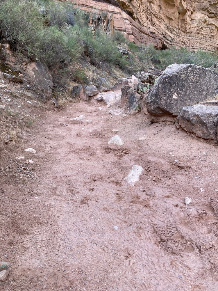
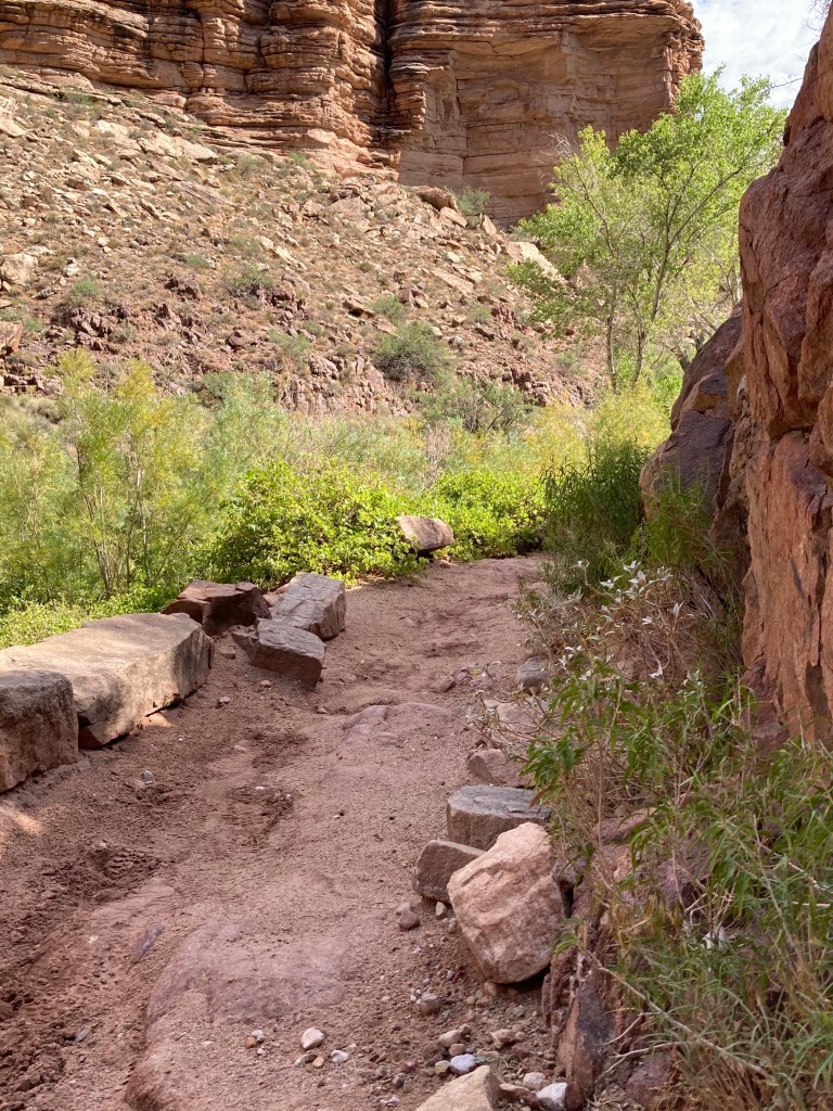
I ambled along in the morning sun, checking the cliffs and landscape. I entered a shaded area with lush growth and watery trail. Had I already missed it? I prepared for failure, and continued on. I came out from the lush growth and the trail was dry again. I was still below Tapeats. I wonderful sight hovered above my left shoulder, a big red unruly basement rock. This had to be the Xgr Granite, granitic pegmatite and aplite. As I continued on it began to taper down and down and down until it stopped at the edge of the trail. “I think this may be it.” I continued walking up trail to see if I could find the Tapeats. I came to a big mess of fallen rocks at the bottom of Tapeats Narrows. Despite my rule to never go off trail, I climbed onto the mess of rocks to see if I could find the lower end of the Tapeats cliff to check for basement rocks. There was nothing I could see here but more fallen rock. I returned to the trail and checked for any other clues. The trail was embedded with the colors of the Tapeats. I hunched over, following the trail back down. Tapeats, Tapeats, Tapeats. I was back at the red granite. I followed that down. Granite, Granite Granite. “This is it.”
I had never taken a panorama photo on my I-phone, but my feet were too far apart for a regular photo. Got it.
Just then my friend caught up with me once again. I showed him what I found. He took photos of me with my feet touching the granite and Tapeats. We hiked to Indian Garden and parted ways at the day hiker’s rest area, and he said he would find me before his hike to the South Rim.
I set up camp. At the water spigot I met up with the backpackers who had checked on me at Bright Angel Campground and given me their shade at Sunscreen Rock. I told them I had found the Great Unconformity and we talked for awhile. They are Navaho. One of them told me that she had tried to find the spot but had never found it. She shared what she had been told about it from her friend in their tradition. I showed her a photo and she said she knew that place and it was where her friend said he found it. Now she would know next time.
My friend came to the 4 pm ranger talk and we exchanged email addresses. He hiked off into into another stormy night to reach to his temporary abode above Verkamp’s Visitor Center. I thought of him as rain beat down on my tent and hoped he was okay. It would have been dark, perhaps a bit lonely and even scary. Once I reached the Rim the next day, I emailed him and learned that he made it out okay. Outside the ice cream shop I saw my other friends. They told me that the others we had been camping with since the storm at the bottom had also made it out.
